Features Research Archives

To Top

Day 3 – Tues. Apr. 14th: Winds and more Winds

• CATEGORIES: Features • TAGS: This site contains affiliate links for which I may be compensated.

<– Day 2 – Mon. Apr. 13th: Rocks, Tracks & Dusty Roads | TRIP OVERVIEW | Day 4 – Wed. Apr. 15th: Salmon and Subway –>

2015-04-14-saltlake-durango4

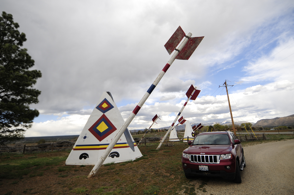
Those arrows barely missed us!

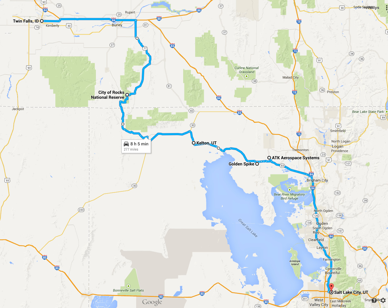
Today we drove from Salt Lake City, Utah, to Durango, Colorado. Brisk winds hounded us over our entire route. At one point as we approached Moab a huge dust devil stacked with tumbleweeds blew across the road in front of us; what a spectacular site! I’m really glad it didn’t blow into us!!

2015-04-14-saltlake-durango-map

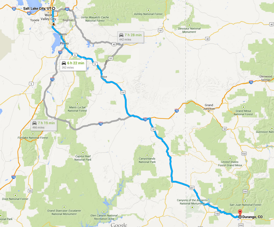
Today we drive from Salt Lake City, Utah, to Durango, Colorado.

Needless to say, the winds squashed any desire we had to jump out and take photos. Besides, we’ve capture the look and feel of this area, as well as the jeeps, during our 2013 trip when we photographed the CJ-2A on Ivan’s sign just south of Moab and the jeep that sits atop Hole in the Rock.

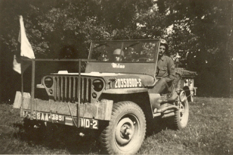
I’d pretty much given up on photos, but then we spotted two jeeps and a bunch of arrows. The winds had subsided, so we got some pics while the shooting was good.

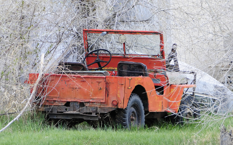
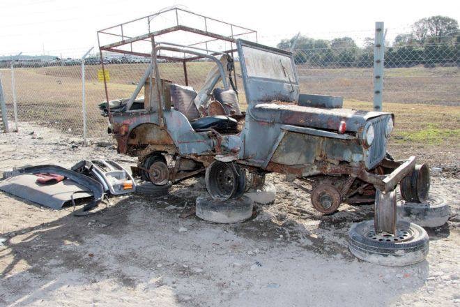
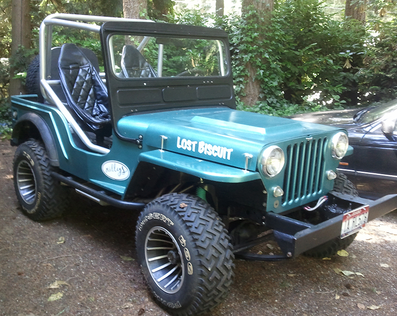
The first jeep I spotted was this CJ-2A, which appeared to be a VEC. It sits off the Colorado State Highway 160 just east of Mesa Verde National Park (which we decided not to visit due to the winds and the fact that we’d both been there).

2015-04-14-saltlake-durango1

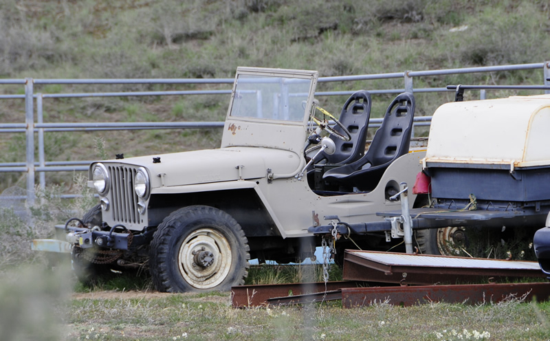
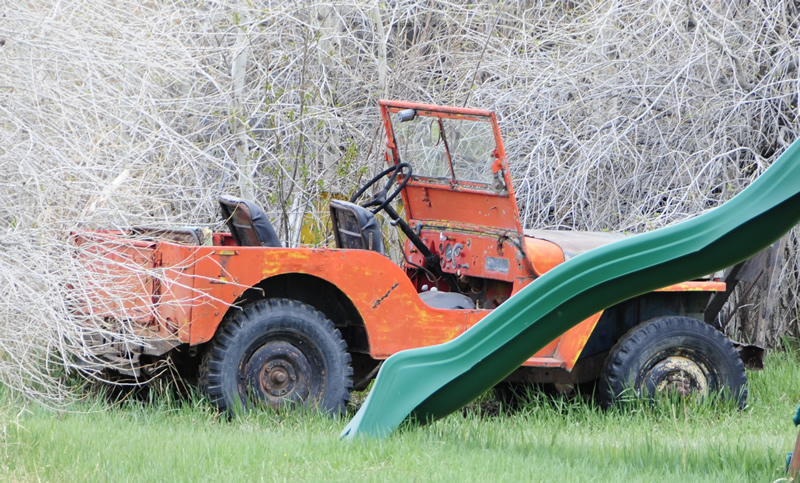
The next jeep we spotted was this CJ-2A in Manco, Colorado. It’s on the east side of town along the main street.

2015-04-14-saltlake-durango2 2015-04-14-saltlake-durango3

Continue reading

[fb_button]
 
To Top

Day 2 – Mon. Apr. 13th: Rocks, Tracks & Dusty Roads

• CATEGORIES: Features • TAGS: This site contains affiliate links for which I may be compensated.

<– Day 1 –  Sun. Apr. 12th: On the Road Again, Finally | TRIP OVERVIEW | Day 3 – Tues. Apr. 14th: Winds and more Winds –>

2015-04-13-city-of-rocks-window

City of Rocks National Reserve

Today’s goal was to drive from Twin Falls to Salt Lake City, which normally takes about 3 hours. I’ve traveled this route so many times that I mark my progress by familiar cracks in the road. And, every time I pass by a sign that announces the exit for City of Rocks, I tell myself I’m going to take that some day. Well, that ‘some’ day was today.

Knowing that at least some of the roads would be unpaved (turns out most were), I calculated the drive would be much longer than three hours. In fact, the drive took 9 hours, some of which included map checks, photo ops, and very short walks. I don’t advise doing this trip unless you have good maps. We lacked cell coverage for most of the day and there are very few helpful signs (not many roads either).

2015-04-13-twinfalls-slc-map

Today we drove from Twin Falls to Salt Lake City via the City of Rocks and lots of gravel roads.

We took off about 8am from Twin Falls and drove east on I-84, before turning on State Highway 77. We quickly found ourselves following the old California Trail, a spur taken by wagon trains that left the Oregon Trail for California.

The first interesting town we encountered was Albion. Near the entrance to the town an old and abandoned Normal School loomed eerily by the road. We weren’t a bit surprised the a nearby sign boasted how spooky the place was. However, if this is your thing, you should check out this website.

2015-04-13-albion2

Haunted? Easy to believe.

2015-04-13-albion1

Normal? She’s trying awfully hard to make me believe that!

When we got to the City of Rocks area, we stopped by the visitor’s center.

2015-04-13-city-of-rocks1

The ranger was friendly and helpful. She explained that travelers heading west on the California Trail found the City of Rocks a unique diversion from the long travels. Wagon trains would camp among the lower rocks. Several of the large rocks have carvings dating as far back as the 1840s.

As for rocks inside the visitors center, we didn’t find many. However, we did find this unexpected gem:

2015-04-13-city-of-rocks-idaho-poster-sign

Idaho State Park poster with a Willys Wagon!

Continue reading

[fb_button]
 
To Top

Day 1 – Sun. Apr. 12th: On the Road Again, Finally

• CATEGORIES: Features • TAGS: This site contains affiliate links for which I may be compensated.

<– Trip Overview | Day 2 – Mon. Apr. 13th: Rocks, Tracks & Dusty Roads –>

2015-04-12-shoshone-falls3

Shoshone Falls Park near Twin Falls, Idaho. When the falls are gushing the water thunders over the areas to the right and left of Ann.

It took most of the morning, but I finally wrangled Ann into the jeep so we could get the heck out of Pasco. Our goal was to make it to Twin Falls, Idaho. It’s not much of a stretch (only 6+ hours), but we did have a specific place to visit: Shoshone Falls, a place I’ve been promising we’d see.

2014-04-12-pasco-twinfalls

Yesterday we drove from Pasco, Washington, to Twin Falls, Idaho.

Since we’ve covered much of the Pasco to Idaho trip in past photos, we won’t bore you with them here — in fact, we didn’t take any of the drive. However, we did have some excitement, which happens whenever my wife drives. Once she is behind the wheel she just goes …. she doesn’t really pay too much attention to signs (though she does follow the speed limit). On more than one occasion she’s driven happily past an exit. This time, we came close to missing the exit, but fortunately I looked up from my eWillys updates just in time to avoid an unplanned detour. She add’s endless unpredictability to our adventures 🙂

We reached the city of Twin Falls just in time to get to Shoshone Falls State Park with some sun left. We’d never visited the park and found it a literal oasis in the desert. We snapped a few photos before quickly realizing our selfie tactics were rusty. We shall work to improve those, so don’t pan us too loudly for our narcissistic desire to self-photograph . . . we are just practicing! Here are a few practice shots at the falls:

2015-04-12-shoshone-falls4

The park was surprisingly beautiful kept with clean grassy landscapes.

2015-04-12-shoshone-falls5

This cool platform rests on a rock peninsula that provides wonderful views of the upstream falls and downstream Snake River.

2015-04-12-shoshone-falls1-lores

Me practicing the art of the selfie. I’d forgotten to move my hand slightly to increase the number of potential views. This is hard work I’m telling’ ya! Now if you look down the river about a half mile you can seen (you really can’t see, you have to imagine) where Evel Knievel tried to jump the river (see video below … not sure why it is age-restricted).

As the sunset, we retired to our motel in Twin Falls.

Tomorrow we will veer off the interstate for our first foray to the City of Rocks, a little known gem in a remote part of southwest Idaho.

<– Trip Overview | Day 2 – Mon. Apr. 13th: Rocks, Tracks & Dusty Roads –>

[fb_button]
 
To Top

June 1944 Photo of Jeep From France

• CATEGORIES: Features This site contains affiliate links for which I may be compensated.

This photo is part of an archive of letters from a Doctor named Greg Alexander to a woman named Wilma he met on a blind date during the war and (spoiler alert) married after he returned. Titled Letter’s to Wilma, the blog tracks Greg’s life as he enters the service, through D-Day, France and Germany. One of the interesting aspects is that jeep he was assigned when he reached France (see below). Anyone know what’s on the bumper? I assume the bar on the front was to carry stretchers? Note the jeep is named Wilma.

Here’s the blog: http://wwii-letters-to-wilma.blogspot.com

1944-wilma-jeep-doctor-greg

[fb_button]
 
To Top

Sears CJ-2A Windshield Extension

• CATEGORIES: Features • TAGS: This site contains affiliate links for which I may be compensated.

Doug shared with me the windshield extension included by Sears when he purchased a soft top in 1971. So, if you see something similar, it was actually a third party modification!

He wrote, “Here are some pics of the windshield extension that came with the Sears full soft top that I purchased in approx. late 1979.I ordered the top for an MB/GPW, so it came with the extension. They sold the same top to fit a cj2a without using the extension. I remember going to a canvas/upholstery shop to have some help with  the doors. For some reason I could not install the doors without some professional help. Can’t recall why.I got home late that night! I was 17 at the time.”

doug-long-cj2a-sears-softop-extension8

doug-long-cj2a-sears-softop-extension7
doug-long-cj2a-sears-softop-extension1 doug-long-cj2a-sears-softop-extension2

Continue reading

[fb_button]
 
To Top

1944 Photo of the 200,000th MB on eBay

• CATEGORIES: Features, Old Images This site contains affiliate links for which I may be compensated.

And who has this MB?

“1944- Ward Canaday, President of Willys-Overland, drives the 200,000 Jeep built in Toledo off the line on April 4, 1944. Mr. Canaday helped the company get a contract to make Jeeps during WWII, producing 363,000 of the total of 648,000 wartime Jeeps.”

View all the information on eBay

1944-04-04-200000-mb-ward-canaday1

1944-04-04-200000-mb-ward-canaday2

[fb_button]
 
To Top

1957 Photo of Ben Carlin’s Half Safe in Ditch on eBay

• CATEGORIES: Features, GPA (SEEP), Old Images This site contains affiliate links for which I may be compensated.

I don’t remember this photo in any of the Half Safe books.

“1957 Press Photo Tiburon Calif, Australian Ben Carlin drove amphibious jeep
This is an original press photo. Tiburon Calif, Australian Ben Carlin drove amphibious jeep around the worldPhoto measures 9.25 x 7.25inches. Photo is dated 12-03-1957.”

View all the information on eBay

1957-12-09-ben-carlin-half-safe-tiburon-crash1

Continue reading

[fb_button]